Reducing the cost of topographic surveys through scope precision
An Easy Way to Reduce the Cost of Commissioning Topographic Surveys
Commissioning a topographic survey hand in hand with the pressures on budgets often result in the award to the lowest cost provider, though not always a survey fit for the intended use. There are a couple of ways to make sure you minimise the unnecessary cost of surveys and ensure that you get the best value for your project. 
The importance of communication is paramount in the early stages. The survey provider must fully understand the intended use of the survey and the extents.
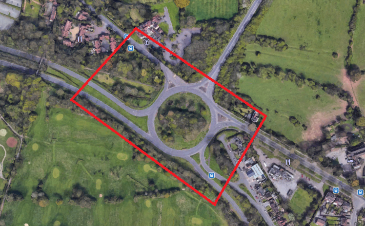
The picture below for example is a typical marked area for a topo survey in red. The boundary includes heavily vegetated areas inside of roundabouts and along the verges, when in fact may not be required. By simply drawing a box on a map and not cutting out the unnecessary areas this instantly runs the risk of the area being included in the quote, which would take time and therefore is unnecessary cost.
RICS (The Royal Institute of Chartered Surveyors) and The Survey Association have some great resources and guides and tick lists that assist consumers with writing a scope of work for a survey. However, surveyors often receive a fully ticked list of RICS requirements – sometimes the full set of requirements will be needed, but it’s important to consider as a full list will equate to a very detailed survey and therefore will drive the cost up. Think about what you really need out of your survey, the scope of work will ultimately decide the costs involved.
It all starts with scope definition and communication therefore is key, discuss your requirements with your survey company to ensure they understand exactly what you need the data for and they can recommend the best course of action from there.
For reference, you can check out industry guidance from The Survey Association.
To get in touch contact our Operations Director, Clif Webb